Figurative language: Idioms pic.twitter.com/SsBaQNgJkQ
— Ms.Thelen (@thelensthinkers) October 27, 2020

A fifth grade blog! Interested in my blog when I taught Kindergarten? Here it is: https://kindersthelen.blogspot.com/
Tuesday, October 27, 2020
Time for some fall-like Idioms!
Friday, September 11, 2020
Should Children Be Paid for Doing Chores?? Read on to see what some fifth graders think...
Yes!!! I am so energized after reading student work submitted through @Schoology on day 1 (or 2 for some). Such a joy to finally read student work! THIS is why I teach. All these voices. Our future. #cpsbest
— Ms.Thelen (@thelensthinkers) September 9, 2020
Should kids get paid to do chores?? Yes/No? pic.twitter.com/S0ZASFFAsb
Take it from this student, parents work very hard and are sacrificing... chores prepare us for the future! She is right, parents are working SO HARD and are SACRIFICING so much right now. Please know that teachers are so thankful for your help right now! #cpsbest pic.twitter.com/YFUy2OA8OQ
— Ms.Thelen (@thelensthinkers) September 9, 2020
First Week: Done!

We did it! We completed week one of virtual learning. We may have had some bumps in the road and some learning curves with the technology, but this class rocked it!!!
In a short amount of time, students have worked to navigate between apps on an iPad. They have learned to use a learning management system, Schoology, AND students submitted assignments!
Students showed up for every Zoom and they gave it their all. Our future looks bright and this WILL be a wonderful year!
Friday, May 15, 2020

Wednesday, February 19, 2020
Learning about America's Regions
Students are working on the following objectives for social studies and science.


- The student will use geographic research to gather and process information to interpret, solve problems, and construct maps.
- The student will name and locate specific regions, states, capitals, river systems and mountain ranges in the US based on historical and current topics.
- Describe and analyze the physical and human characteristics of the region.
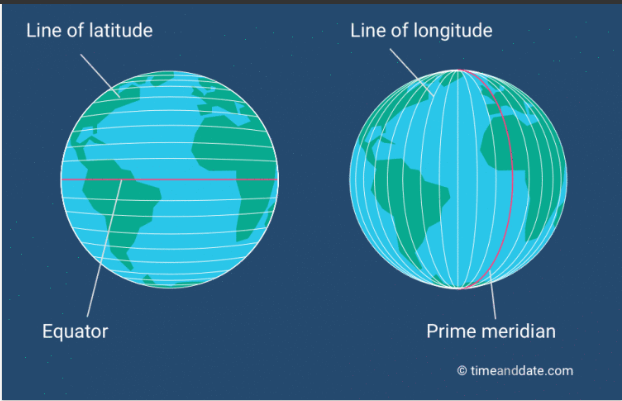
Students reviewed latitude and longitude before starting the research!


Students will be constructing a map including the following:
On the USA map independently complete the following in pencil first.
Sunday, February 16, 2020
Civil War Food Tasting
Thank you to our trusty volunteer, Mrs. F, the class got to taste hardtack and President Lincoln's favorite cookie recipe. Students actually did not mind the hardtack as much as one might think! They were encouraged to use their back teeth!


Friday, January 24, 2020
Beach Simulation
Students working on a simulated beach to see how the geosphere and hydrosphere interact. Weathering, erosion, and deposition. #cpsbest @Szydlowskim pic.twitter.com/aqodfj1VFO
— Shelli Thelen (@ShelliThelen) January 24, 2020
Subscribe to:
Posts (Atom)